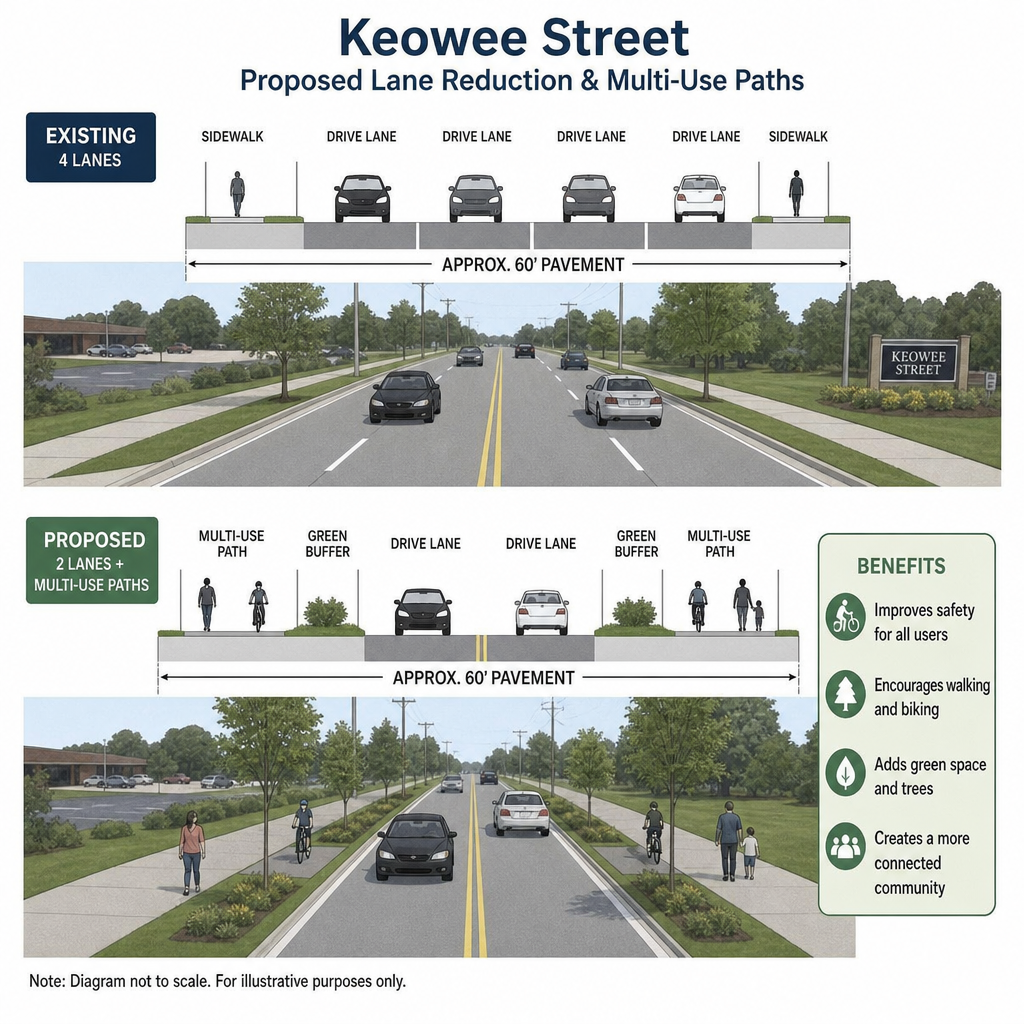
Dayton’s Keowee Street safety project would reduce the roadway from seven lanes to five between East Fifth Street and East Monument Avenue, adding multi-use paths, landscaping, and signal upgrades. The City of Dayton’s plan aims to make the corridor more comfortable for walking and bicycling while calming vehicle traffic. Understanding the design, and separating planned improvements from confirmed construction notices, can help residents prepare. (transportation.ohio.gov)
Call (937) 884-4474 or request a free consultation today to speak with an experienced Dayton personal injury attorney at Buckeye Law Group.
What will change on Keowee Street?
The proposed improvements reallocate part of Keowee Street’s roadway to paths on both sides rather than keeping all seven travel lanes. Dayton describes an 11-foot-wide multi-use path or walkway on each side, alongside an 8-foot-wide tree lawn with new trees. ODOT also identifies traffic signal upgrades as part of the project. (daytonohio.gov)
Those elements serve different purposes within the same community safety project:
- Lane Reduction: Reassigns roadway space and supports the project’s traffic-calming objective.
- Multi-Use Paths: Provide space intended for people walking and bicycling outside the vehicle travel lanes.
- Tree Lawns: Establish landscaped space alongside the paths rather than using the entire corridor width for motor vehicles.
- Signal Upgrades: Address intersection equipment as part of the broader roadway improvement.
The distinction between a shared-use path and a painted bicycle lane matters. Residents should look to the city’s description of paths on both sides when evaluating the proposal, rather than assuming the project consists only of new pavement markings.
How could fewer lanes improve roadway safety?
Reducing lanes can improve safety when the redesigned street better matches its traffic demand and gives people clearer, more manageable places to travel. Federal Highway Administration guidance explains that roadway reallocation can support lower speeds, shorter pedestrian crossings, and space for other transportation modes. The benefits depend on the particular design, not simply removing pavement available to cars. (highways.fhwa.dot.gov)
On multilane roads, drivers may change lanes around slower traffic, while pedestrians must judge vehicles approaching across several lanes. FHWA identifies sudden lane changes, differences in vehicle speeds, and the number of lanes pedestrians must cross among the safety concerns associated with wide, undivided roads. Reconfiguring a street can address some of those conflicts. (highways.dot.gov)
However, a crucial qualification belongs in any discussion of Keowee Street: much of the familiar road-diet research concerns four-lane roads converted to three lanes. Keowee’s proposed seven-to-five-lane change is different. It would be misleading to take a crash-reduction percentage from that research and present it as a forecast for this project. (cmfclearinghouse.fhwa.dot.gov)
The reasonable expectation is an opportunity for safer operation, not a guarantee. The questions to evaluate afterward are whether speeds become more appropriate, crossings become easier to navigate, and serious conflicts decline, not whether the street merely looks narrower.
How could the new walking paths help pedestrians?
The planned paths could give people a more usable place to walk along Keowee Street, with landscaped space separating them from vehicle travel. Their practical value depends on continuity, accessible connections, and safe crossings at driveways and intersections. A wide path is useful, but it cannot eliminate every place where vehicles and people meet.
Consider a person walking several blocks to an appointment. A continuous path can make that trip more straightforward, but every driveway still deserves attention. Drivers entering or leaving properties cross the path, creating potential conflicts even though the person walking is outside the roadway. FHWA emphasizes that driveways, as well as major intersections, are locations where vehicle, pedestrian, and bicycle movements intersect. (highways.dot.gov)
Shared-use paths also need to accommodate users traveling at different speeds. Someone walking slowly, a person using a mobility device, and someone bicycling all need understandable space and predictable interactions. ODOT’s design guidance treats safety, accessibility, comfort, and year-round convenience as important characteristics of transportation paths. (transportation.ohio.gov)
When reviewing the finished corridor, residents can use these practical questions:
- Does the path connect continuously to the next block?
- Are curb ramps and crossing approaches clear and usable?
- Can drivers and path users see each other at driveways?
- Are intersection routes understandable without guesswork?
- Does maintenance keep the usable path clear throughout the year?
These are useful checkpoints, not claims that every detail has already been finalized or installed.
Construction timing needs careful interpretation
ODOT’s project listing contains conflicting schedule information. Its narrative says construction was expected to begin in summer 2026, while its project-details fields list a fall 2026 start and summer 2027 completion. The listing also labels the project “Pre-construction.” Those entries should not be treated as confirmation of the exact conditions on Keowee Street today.
For anyone searching for Dayton road closures, a project overview is only the starting point. ODOT directs travelers to its Montgomery County traffic-impact information, which it says is updated weekly. Check the notice covering your travel date rather than relying on an earlier announcement or assuming a seasonal construction estimate establishes a particular closure.
A useful Dayton traffic pattern update should identify the affected blocks, travel direction, dates, lane restrictions, and any posted detour. Before changing a regular trip, look for those details in an official notice. If the information is unclear, seek clarification rather than assuming an entire corridor is closed.
Safer habits during the transition
A redesigned street requires attention even from people who know the route well. Ohio’s traffic-safety guidance warns that work zones can involve shifted lanes, narrower travel space, closures, and equipment. Changed conditions can remain hazardous even when workers are not visible. (otso.ohio.gov)
Use this checklist when traveling through an active work area:
- Read Signs Before Committing To A Lane: Slow down at the first warning and leave room to respond to changed conditions.
- Avoid Last-Second Maneuvers: Watch the route ahead rather than assuming familiar markings still apply.
- Keep Attention On People As Well As Vehicles: Watch for workers, pedestrians, and cyclists near temporary travel routes.
- Follow Designated Pedestrian Routes: Do not improvise a shortcut through an active construction area.
- Allow Extra Time: Give yourself room to follow temporary controls without rushing.
After construction, the same basic principle applies: read the street as it is, not as you remember it. ODOT’s “Read the Road” initiative emphasizes yielding, appropriate speeds, and awareness of people walking and bicycling. Infrastructure improvements work alongside those behaviors, not in place of them. (transportation.ohio.gov)
Dayton and Montgomery County Resources for Keowee Street Travelers
Residents, commuters, pedestrians, and bicyclists traveling along Keowee Street between East Fifth Street and East Monument Avenue may have questions about construction activity, changing traffic patterns, roadway hazards, or accident reporting. Several local and state agencies provide information that can help individuals stay informed and address safety concerns.
Keowee Street Construction Updates and Project Information
Ohio Department of Transportation (ODOT), District 7
ODOT maintains information about the Keowee Street Safety Improvements project under Project ID 120094. Its project page outlines the proposed roadway changes, including the reduction from seven to five travel lanes, multi-use paths, landscaping, and traffic signal improvements.
Residents can use the following resources to distinguish long-term project plans from current traffic restrictions:
- Keowee Street Project Information: ODOT Project 120094
- Montgomery County Traffic Advisories: ODOT Traffic Impacts
- Traffic Conditions And Incident Information: OHGO.com
- ODOT District 7 Public Information: (937) 497-6959
The City of Dayton’s Projects Changing Dayton page also provides information about the planned Keowee Street improvements. Before traveling through the corridor, motorists should check for current traffic restrictions that may affect their intended routes. Published project timelines do not necessarily reflect which lanes or intersections are subject to restrictions on a given day.
Reporting Traffic Safety Concerns in Dayton
Dayton Police Department – Traffic Services Unit
The Dayton Police Department’s Traffic Services Unit investigates traffic-related violations and follows up on public complaints involving speeding, parking, and other traffic concerns. Residents who observe recurring unsafe driving behavior along Keowee Street can contact:
- Traffic Services Unit: (937) 333-1149
- Dayton Police Non-Emergency Line: (937) 333-2677
- Emergencies Involving Immediate Danger Or Injuries: 911
For concerns involving damaged infrastructure, obstructed pedestrian facilities, or other municipal service issues, residents can submit a request through the Dayton Delivers service system.
When reporting a roadway concern, provide the nearest intersection, direction of travel, approximate time, and a clear description of the problem. Identifying whether an issue involves temporary construction controls or existing roadway conditions can also help direct the concern to the appropriate agency.
Obtaining a Traffic Crash Report in Dayton
Dayton Police Department – Records and Crash Reports
Individuals involved in a collision along Keowee Street may need documentation for insurance purposes or to better understand the information recorded by responding officers. The Dayton Police Department provides information about requesting accident reports through its official website.
- Dayton Police Department: 335 W Third St, Dayton, OH 45402
- Non-Emergency Telephone: (937) 333-2677
- Online Resources: Dayton Police Traffic Accident Reports
- Statewide Crash Report Search: Ohio Department of Public Safety
An important distinction is that not every collision results in a formal police crash report. Under the Dayton Police Department’s published reporting policy, officers complete formal Ohio Traffic Crash Reports for certain incidents, including crashes involving qualifying injuries, hit-and-run drivers, suspected impaired driving, or vehicles requiring towing.
The Ohio Department of Public Safety also notes that reports may take several weeks to appear in its database. Its online copies are not official documents; individuals who need an official report should contact the investigating law enforcement agency.
Montgomery County Court Information
Montgomery County Common Pleas Court – General Division
Some personal injury disputes arising from motor vehicle, pedestrian, or bicycle accidents may become civil court proceedings. The appropriate court depends on the nature of the claim, the amount in dispute, and applicable jurisdictional requirements. Dayton and Montgomery County residents seeking information about civil court procedures, court records, or available public court services may consult the following local judicial resources:
- Address: 41 N Perry St, Dayton, OH 45422
- Telephone: (937) 225-6000
- Website: Montgomery County Common Pleas Court
The court provides procedural information but cannot offer individualized legal advice.
What to Document Following a Collision Near Keowee Street
If a collision occurs during construction or after the roadway changes are completed, the conditions present at the time may become important to understanding what happened. When it is safe to do so, individuals may find it helpful to document:
- The exact intersection, driveway, or block where the collision occurred.
- Traffic signs, lane markings, signals, and temporary construction barriers.
- Photographs of vehicle positions, visible damage, and surrounding roadway conditions.
- Contact information for witnesses and the responding law enforcement agency.
- Medical evaluations and records relating to any reported injuries.
Temporary traffic controls may change or be removed as construction progresses. Preserving accurate information about the scene can help insurers, investigators, and attorneys evaluate the circumstances without relying solely on later roadway conditions.
These resources are intended to help Dayton residents obtain reliable local information and understand available reporting procedures. They do not establish liability for any individual collision or suggest that the Keowee Street improvements have caused an accident.
Measure success beyond traffic speed
A useful evaluation should consider both safety and everyday access. Dayton’s broader Safe Streets and Roads for All effort includes monitoring progress toward eliminating fatal and serious injuries. That provides a more meaningful benchmark than judging a project only by how quickly a driver passes through it. (daytonohio.gov)
For Keowee Street, useful measures to request would include before-and-after speeds, crash severity, pedestrian crossing conditions, and peak-period queues. Residents could also document recurring visibility problems, blocked paths, or confusing markings. These are suggested evaluation topics, not a claim that project-specific results have already been published. Feedback is most useful when it is specific. Instead of reporting that an intersection “feels unsafe,” identify the location, direction of travel, approximate time, and movement involved.
Legal questions belong to individual circumstances
Individuals injured in a collision along Keowee Street or elsewhere in Dayton may benefit from consulting a Dayton pedestrian accident attorney or car accident lawyer to better understand their legal rights and potential options for pursuing compensation. Although proposed roadway improvements are intended to enhance traffic safety, their existence does not independently establish negligence or liability for a particular accident. Determining legal responsibility requires a careful evaluation of the circumstances surrounding the collision, available evidence, and applicable Ohio laws.
For an initial consultation, prepare questions about relevant experience, who will handle the matter, communication, fees, and expenses. Ask what information the attorney needs to evaluate your circumstances rather than expecting an outcome based on the project’s existence. The American Bar Association recommends discussing experience, case assessment, and costs when choosing counsel. (americanbar.org)
Improving Roadway Safety and Accessibility Along Keowee Street in Dayton
The proposed Keowee Street improvements represent an opportunity to strengthen roadway safety, improve pedestrian and bicycle access, and create a more accessible transportation corridor in Dayton. However, the project’s success should be measured by more than the reduction in travel lanes. Important considerations include whether the redesigned roadway supports safer vehicle speeds, provides continuous and accessible walking and bicycling routes, improves visibility at intersections, and reduces potential conflicts among roadway users.
As the Keowee Street improvement project advances, Dayton residents and individuals traveling through the corridor should regularly review official updates from the City of Dayton and the Ohio Department of Transportation for the latest construction schedules, lane restrictions, temporary closures, and changes to traffic patterns that may affect motorists, pedestrians, and bicyclists. Reporting specific roadway hazards, following posted traffic controls, and remaining attentive to changing conditions can help support safer travel throughout the transition. Ultimately, the long-term effectiveness of the Keowee Street redesign will depend on how well the completed improvements serve everyone who uses the corridor, supported by measurable safety outcomes and continued maintenance.
Call (937) 884-4474 or request a free consultation today to speak with an experienced Dayton personal injury attorney at Buckeye Law Group.
Legal Disclaimer: This article is provided by Buckeye Law Group for general educational and informational purposes and does not constitute individualized legal or medical advice. The content discusses Dayton, Ohio, roadway safety initiatives, local traffic conditions, motor vehicle accidents, and personal injury considerations affecting Dayton and Montgomery County residents. References to Ohio traffic laws, accident reporting procedures, insurance coverage, negligence, potential compensation, and legal filing deadlines are intended to help injured individuals and their families better understand their rights and available resources following an accident. Every personal injury claim involves unique circumstances, and determining liability or eligibility for compensation requires a careful evaluation of the available evidence, applicable Ohio laws, and specific facts of the case. Reading this article or contacting Buckeye Law Group’s Dayton personal injury attorneys does not, by itself, establish an attorney-client relationship. Individuals seeking guidance regarding a particular accident or injury should consult a qualified Ohio personal injury attorney. Past case results do not guarantee or predict future outcomes.
Dayton’s Keowee Street Safety Project: How Lane Reductions and New Walking Paths Could Improve Roadway Safety
Dayton’s Keowee Street safety project would reduce the roadway from seven lanes to five between East Fifth Street and East Monument Avenue, adding multi-use paths, landscaping, and signal upgrades. The
Dayton I-75 Construction in November 2026: Lane Closures, Traffic Shifts, and Work-Zone Safety
Motorists traveling along I-75 through Dayton, Ohio, in November 2026 should be aware of multiple construction projects that may affect travel times, lane configurations, and access to nearby interchanges. According
Columbus I-70/I-71 Construction in November 2026: Ramp Closures, Detours, and Driver Safety
Motorists traveling through downtown Columbus, Ohio, in November 2026 should prepare for temporary traffic disruptions as construction continues along the I-70/I-71 corridor. Overnight interstate restrictions, ramp closures, and designated detours
Mansfield’s Main Street Transformation: What Drivers and Pedestrians Should Know About Downtown Traffic Changes in 2026
As Mansfield completes its 2026 Main Street Transformation, residents and visitors should understand how the redesigned streets affect access to downtown businesses, public buildings, pedestrian crossings, and nearby parking areas.
Toledo’s Douglas Road and Monroe Street Intersection Improvements: What Drivers and Pedestrians Should Know in 2026
The City of Toledo identifies the Douglas Road and Monroe Street intersection as a 2026 improvement project intended to support pedestrian safety, driver safety, and better pavement conditions. For people
Springfield’s South Limestone Street Safety Improvements: What Drivers Should Know
South Limestone Street in Springfield, Ohio, is the focus of safety improvements intended to reduce conflicts between vehicles entering, leaving, and traveling along the corridor. The Ohio Department of Transportation’s
Middletown’s 2026 Safe Streets and Roads for All Initiative: What Residents Should Know
Middletown, Ohio’s Safe Streets and Roads for All (SS4A) effort is best understood as a road-safety planning-and-delivery process funded through the U.S. Department of Transportation. For residents following this community
Euclid’s Lakeshore Boulevard Pedestrian Safety Improvements: What Drivers and Walkers Should Know
Euclid’s Lakeshore Boulevard pedestrian safety improvements aim to enhance roadway visibility, provide safer crossing opportunities, and strengthen connections between Downtown Euclid, Sims Park, and the Lake Erie waterfront. The City
Cincinnati’s Victory Parkway Safety Improvements: What Drivers and Pedestrians Should Know in 2026
Cincinnati’s Victory Parkway Improvement Project represents a significant investment in roadway safety, pedestrian accessibility, and transportation infrastructure. Overseen by the Cincinnati Department of Transportation & Engineering (DOTE), the project includes
What Greater Akron’s latest crash data reveals about roadway safety and serious injuries
Greater Akron’s latest regional crash report shows fewer crashes overall, but serious injuries remain a concern. The Akron Metropolitan Area Transportation Study’s 2022–2024 analysis separates encouraging declines in fatalities from

Buckeye Law Group represents people injured in auto accidents, slip and falls, workplace accidents and more in Ohio. Contact us today to learn more.
© 2026 Todos los derechos reservados | The Buckeye Law Group Inc. Políticade privacidad Mapa del sitio
Ubicaciones de las oficinas
- Akron Office 388 S Main St #400 Akron, OH 44311 (330) 426-0288
- Cincinnati Office 201 E 5th St Ste 1910 Cincinnati, OH 45202 (513) 547-2445
- Cleveland Office 127 Public Square Ste 1540 Cleveland, OH 44114 (216) 677-5490
- Columbus Office 20 E Broad St Suite 300 Columbus, OH 43215 (614) 482-3793
- Dayton Office 70 Birch Alley Ste 240 Dayton, OH 45440 (937) 884-4474
- Euclid Office 25701 N Lakeland Blvd Suite 113-C, Cleveland, OH 44132 (216) 405-2626
- Mansfield Office 305 E Main St Ste 6A, Mansfield, OH 44904 (567) 210-2606
- Findlay Office 7430 Timberstone Dr unit 101a, Findlay, OH 45840 419-873-5119
- Mentor Office 7537 Mentor Ave Ste 101, Mentor, OH 44060 (440) 306-3536
- Middletown Office 300 N Main St #400, Middletown, OH 45042 (326) 800-9150
- Parma Office 1257 Rockside Rd #A, Parma, OH 44131 (216) 279-1664
- Springfield Office 2100 E High St Ste TL3, Springfield, OH 45505 (937) 806-5791
- Toledo Office 3950 Sunforest Ct Ste 200, Toledo, OH 43623 (567) 483-3883
- Westlake Office 26404 Center Ridge Rd Ste B2, Westlake, OH 44145 216-247-0565
- Whitehall Office 5340 E Main St Ste 203, Whitehall, OH 43213 (380) 257-5206
- Youngstown Office 306 Churchill Hubbard Rd, Youngstown, OH 44505 (234) 225-0683
Contáctenos
© 2026 Todos los derechos reservados | The Buckeye Law Group Inc. Políticade privacidad Mapa del sitio