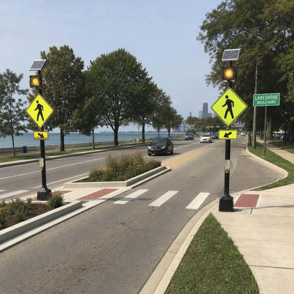
Euclid’s Lakeshore Boulevard pedestrian safety improvements aim to enhance roadway visibility, provide safer crossing opportunities, and strengthen connections between Downtown Euclid, Sims Park, and the Lake Erie waterfront. The City of Euclid incorporated landscaped pedestrian refuge islands, enhanced crosswalks, and flashing warning beacons into its downtown improvement project, with additional safety improvements planned east of East 228th Street. For motorists and pedestrians, understanding these roadway changes, designated crossings, and applicable Ohio traffic laws is essential to navigating the corridor safely. This guide examines the improvements, their potential safety benefits, and practical considerations for residents traveling along Lakeshore Boulevard. (s3.countyplanning.us)
Call (216) 405-2626 or request a free consultation today to speak with our experienced Euclid pedestrian accident lawyers at Buckeye Law Group.
What pedestrian safety improvements were added to Lakeshore Boulevard?
The downtown project installed five landscaped medians, with three incorporating pedestrian crosswalks and rapid-flashing beacons, according to Euclid’s September 2024 council materials. A county planning report also documents a stamped crosswalk and 24 street trees. These additions combine defined crossing locations with landscaping rather than treating pedestrian safety as a pavement-marking project alone. (cdn.euclidlibrary.org)
That distinction matters because the city’s October 3, 2022 announcement described five planned pedestrian safety islands with enhanced crossing features. The later council record provides a more specific account of the installed arrangement: five medians, three with beacon-equipped crossings. Readers should not assume every landscaped island is a designated crossing. The main features serve different purposes:
- Pedestrian Refuge Islands: Provide a place to pause partway across the roadway before completing the crossing.
- Rectangular Rapid-Flashing Beacons, Or RRFBs: Use flashing yellow lights to draw drivers’ attention to people at marked crossings.
- Designated Crosswalks: Establish recognizable places for pedestrians to cross and drivers to anticipate them.
- Landscaped Medians And trees: Add greenery alongside the roadway’s safety features. (highways.dot.gov)
Together, these elements illustrate pedestrian-friendly design: the street provides both a visible crossing point and a place to wait, rather than relying on a person to negotiate the entire road at once. Federal Highway Administration guidance identifies refuge islands and RRFBs as complementary pedestrian safety treatments.
How do refuge islands and flashing beacons make crossing safer?
Refuge islands allow pedestrians to divide a crossing into stages, while flashing beacons make the crossing activity more noticeable to approaching drivers. The island provides a midpoint waiting area; the beacon addresses visibility and driver awareness. Neither replaces the need for drivers to yield appropriately or for pedestrians to check traffic before entering the roadway.
Consider someone crossing toward a downtown destination. Instead of needing a suitable opportunity across the full roadway, that person can reach the designated refuge and assess the remaining crossing separately. This is the practical purpose of the island—not simply decoration in the center of the street.
RRFBs add an attention-getting signal at an otherwise unsignalized crossing. The Federal Highway Administration explains that the flashing pattern can be activated by a pushbutton or automatic detection, depending on the installation. Follow the instructions at the particular crossing rather than assuming every beacon operates identically. (highways.dot.gov)
Pedestrians using Lakeshore Boulevard’s designated crossings in Euclid should activate the flashing warning beacon when a pushbutton is provided and assess approaching traffic before entering the roadway. According to the Federal Highway Administration, rectangular rapid-flashing beacons improve pedestrian visibility and alert motorists to crossing activity, but they do not guarantee that vehicles will stop. Under Ohio Revised Code § 4511.46, drivers must yield to pedestrians in crosswalks under specified conditions, while pedestrians must avoid entering the path of an immediate hazard. When using a pedestrian refuge island, reassess traffic conditions before crossing the remaining lanes.
Drivers need to anticipate crossings and follow the new layout
Approach the improved corridor expecting pedestrian activity, not just changes in landscaping. Look toward both sidewalks and any refuge island, slow as conditions require, and leave room to stop before the crosswalk. National Highway Traffic Safety Administration guidance recommends yielding to pedestrians in crosswalks and stopping well back so other drivers can see people crossing. (nhtsa.gov)
Three habits are especially useful:
- Never Pass A Vehicle Stopped At A Crosswalk: It may be hiding a person crossing in front of it.
- Check The Crosswalk Before Turning: A person may enter your path as you focus on vehicle traffic.
- Allow Extra Caution In Darkness Or Poor Weather: Reduced visibility makes early scanning especially important.
There is also a specific downtown layout issue worth remembering. In an August 2023 project update, the city explained that the eastbound curbside space approaching East 222nd Street had been a parking lane, not an official right-turn lane. A concrete curb extension was installed to discourage drivers from using it incorrectly. Follow current lane markings rather than a turning habit learned before the work. (cdn.euclidlibrary.org)
For trip planning, do not interpret the improvements as a promise of unchanged travel times. The practical adjustment is to allow for pedestrian crossings and follow the current street configuration. Safe passage through downtown includes making space for people reaching businesses, parks, and transit, not simply maintaining uninterrupted vehicle movement. (nhtsa.gov)
Safe walking routes connect downtown, transit, and the lakefront
The lakeshore improvements extend beyond the act of crossing the boulevard. The city’s downtown project included an approximately 1,600-foot-long, 10-foot-wide paved trail connecting a plaza near Lakeshore Boulevard and East 228th Street with Sims Park. Its purpose was to strengthen connections among Downtown Euclid, Sims Park, and the Lakefront Trail.
Euclid’s Lakeshore Boulevard Water Main and Walkability Project also included plans for an ADA-accessible transit waiting plaza near East 228th Street, connecting public transportation with pedestrian infrastructure and a paved trail extending toward Sims Park. According to the City of Euclid, the approximately 1,600-foot trail was designed to improve access between Downtown Euclid, Sims Park, and the Lakefront Trail. These improvements highlight the importance of accessible pedestrian routes, designated crossings, and convenient transit connections, particularly for residents with mobility limitations. For pedestrians and transit riders, safe travel depends on more than individual improvements; it requires connected routes that accommodate the entire journey.
When choosing a walking route, prioritize designated crossings and the connecting paths rather than the shortest straight-line route. Watch for vehicles entering and leaving driveways, and continue checking traffic even when a driver appears to have noticed you. NHTSA recommends predictable crossing behavior and cautions pedestrians against assuming they have been seen. (crashstats.nhtsa.dot.gov)
What funding supported the work, and what is the project’s status?
The original downtown improvements drew on several funding sources, and later records identify that phase as completed. A separate construction notice dated November 1, 2024 announced work between East 228th Street and Luikart Drive. Those are distinct project stages, so the original downtown scope should not be confused with the later eastward extension. (s3.countyplanning.us)
A county planning report adopted June 3, 2024 summarizes the original funding contributions:
| Funding Source | Reported Contribution | Supported Work |
|---|---|---|
| Cleveland Water Department | Approximately $400,000 | Water-main replacement |
| Cuyahoga County 50/50 Program | Approximately $500,000 | Medians, crossing improvements, and trees |
| Ohio Environmental Protection Agency | Approximately $90,000 | Paved trail using recycled tires and other green materials |
These are reported contributions, not a complete project-cost statement. The utility component replaced approximately 1,500 feet of water main between East 222nd and East 228th streets, alongside resurfacing and walkability work. The city described recurring water-line breaks affecting downtown businesses as a reason for the replacement. Bundling the work addressed an underground infrastructure problem while changing how people use the street above it.
For the later phase, the November 2024 notice anticipated construction beginning the week of November 4, continuing through year-end, with possible finishing work the following spring. That is a historical schedule, not confirmation of today’s construction conditions. Before traveling, check current City of Euclid notices and posted restrictions rather than relying on that older announcement. (cityofeuclid.gov)
A corridor improvement within a broader safety effort
The eastward project had a documented safety rationale. September 2024 council materials state that ODOT reviewed the East 228th–Luikart Drive segment after crashes damaged a signal mast arm, traffic-control box, and bus shelter. ODOT recommended tree-planted medians and pedestrian improvements as an engineering response. (cdn.euclidlibrary.org)
The work also fits Euclid’s broader emphasis on connected travel. City Council accepted the Pedestrian & Bicycle Safety Action Plan on March 4, 2024, supporting safer links among neighborhoods, employment, services, recreation, and regional destinations. That context matters: safe walking routes need continuity beyond an individual crosswalk. (countyplanning.us) Drivers should approach crossings ready to yield and follow current markings; walkers should use designated crossings, activate beacons as instructed, and check each stage of the road. The infrastructure supports safer trips, while attentive behavior helps it work as intended.
Euclid, Ohio, Pedestrian Safety Resources, Police Reports, and Local Courts
Residents involved in pedestrian accidents along Lakeshore Boulevard can access several local resources for obtaining crash reports, reviewing roadway improvements, and understanding legal procedures. The following agencies provide official information for Euclid and surrounding Cuyahoga County communities.
Euclid Police Department
Address: 545 E 222nd Street, Euclid, OH 44123
Non-Emergency: (216) 731-1234
The Euclid Police Department maintains motor vehicle crash reports and other public records. Individuals seeking documentation following a pedestrian accident can contact the department’s Records Division or use its online crash-report resources. For emergencies involving immediate danger or injuries requiring urgent assistance, call 911.
Euclid Municipal Court
Address: 555 East 222nd Street, Euclid, OH 44123
Phone: (216) 289-2888
The Euclid Municipal Court handles traffic matters, misdemeanor offenses, and certain civil claims within its jurisdiction. Residents can review court information, available forms, and case records through its official website. Not every pedestrian injury lawsuit belongs in municipal court; jurisdiction depends on the nature and value of the claim.
City of Euclid Pedestrian Safety and Construction Resources
Improving pedestrian and bicycle safety in Euclid requires continued infrastructure investment, thoughtful planning, and community awareness. The City of Euclid provides residents with information about roadway construction, infrastructure improvements, and municipal services. Additionally, the Euclid Pedestrian & Bicycle Safety Action Plan, accepted by City Council on March 4, 2024, outlines opportunities to strengthen pedestrian and bicycle connections throughout the community. As these initiatives move forward, Euclid residents can stay informed about proposed improvements, remain attentive to changing roadway conditions, and take an active role in promoting safer streets for pedestrians, bicyclists, and motorists alike.
Call (216) 405-2626 or request a free consultation today to speak with our experienced Euclid pedestrian accident lawyers at Buckeye Law Group.
Legal Disclaimer: This article is provided by Buckeye Law Group for general educational and informational purposes and does not constitute individualized legal or medical advice. The content discusses Euclid, Ohio, pedestrian safety initiatives, Lakeshore Boulevard infrastructure improvements, designated pedestrian crossings, local roadway conditions, pedestrian accidents, and legal considerations involving personal injury claims. References to Ohio pedestrian safety laws, traffic regulations, accident reporting procedures, insurance coverage, negligence, potential compensation, and filing deadlines are intended to help Euclid and Cuyahoga County residents better understand their legal rights and available resources following a pedestrian accident. Every personal injury case involves unique circumstances, and determining liability or eligibility for compensation requires an evaluation of the available evidence, applicable Ohio laws, and individual facts. Reading this article or contacting Buckeye Law Group’s Euclid pedestrian accident lawyers does not, by itself, establish an attorney-client relationship. Individuals seeking legal guidance about their specific circumstances should consult a qualified Ohio personal injury attorney. Past case results do not guarantee or predict future outcomes.
Euclid’s Lakeshore Boulevard Pedestrian Safety Improvements: What Drivers and Walkers Should Know
Euclid’s Lakeshore Boulevard pedestrian safety improvements aim to enhance roadway visibility, provide safer crossing opportunities, and strengthen connections between Downtown Euclid, Sims Park, and the Lake Erie waterfront. The City
Cincinnati’s Victory Parkway Safety Improvements: What Drivers and Pedestrians Should Know in 2026
Cincinnati’s Victory Parkway Improvement Project represents a significant investment in roadway safety, pedestrian accessibility, and transportation infrastructure. Overseen by the Cincinnati Department of Transportation & Engineering (DOTE), the project includes
What Greater Akron’s latest crash data reveals about roadway safety and serious injuries
Greater Akron’s latest regional crash report shows fewer crashes overall, but serious injuries remain a concern. The Akron Metropolitan Area Transportation Study’s 2022–2024 analysis separates encouraging declines in fatalities from
Why Is St. Clair Avenue One of Cleveland’s Most Dangerous Roads? Crash Data and Safety Improvements Explained
St. Clair Avenue’s danger comes into focus when you look beyond fender-benders to deaths and life-changing injuries. Cleveland reports at least 14 people killed and 79 seriously injured between East
Dayton’s 2026 Road Safety Action Plan: What Local Crash Data Reveals About Dangerous Driving Conditions
The City of Dayton, Ohio, has adopted a comprehensive Safe Streets and Roads for All (SS4A) Safety Action Plan to address traffic fatalities, serious injuries, and hazardous roadway conditions throughout
Cleveland’s 2026 Daylight Saving Time Change: Earlier Darkness, Pedestrian Safety, and Ohio Traffic Laws
Cleveland’s daylight saving time ends on Sunday, November 1, 2026, at 2:00 a.m., when clocks move backward one hour and Northeast Ohio returns to Eastern Standard Time (EST). While the
Halloween Weekend 2026 in Dayton: Impaired Driving Risks, Free Rideshare Resources, and Ohio Accident Laws
Halloween weekend brings celebrations throughout Dayton, Ohio, but increased nighttime traffic, pedestrians, and alcohol-related activities also create important safety concerns. Whether you are attending an event in downtown Dayton, visiting
Halloween Pedestrian Safety Near Ohio State University: Columbus Crosswalk Laws, Accident Risks, and What to Do If You’re Injured
Halloween weekend brings students, residents, and visitors throughout Columbus, particularly around The Ohio State University and the surrounding University District. As people travel between campus, restaurants, residential neighborhoods, and entertainment
Can You Pursue Compensation for a Traumatic Brain Injury After an Ohio Car Accident?
A traumatic brain injury sustained in an Ohio car accident can have significant and lasting consequences for an individual’s health, financial stability, and quality of life. When another party’s negligence
How Long After a Car Accident Can Concussion Symptoms Appear?
A concussion can cause symptoms immediately after a crash or several hours or days later. Sometimes a person first recognizes changes in sleep, mood, concentration, or memory a week or

Buckeye Law Group represents people injured in auto accidents, slip and falls, workplace accidents and more in Ohio. Contact us today to learn more.
© 2026 All Rights Reserved | The Buckeye Law Group Inc. Privacy Policy Sitemap
Office Locations
- Akron Office 388 S Main St #400 Akron, OH 44311 (330) 426-0288
- Cincinnati Office 201 E 5th St Ste 1910 Cincinnati, OH 45202 (513) 547-2445
- Cleveland Office 127 Public Square Ste 1540 Cleveland, OH 44114 (216) 677-5490
- Columbus Office 20 E Broad St Suite 300 Columbus, OH 43215 (614) 482-3793
- Dayton Office 70 Birch Alley Ste 240 Dayton, OH 45440 (937) 884-4474
- Euclid Office 25701 N Lakeland Blvd Suite 113-C, Cleveland, OH 44132 (216) 405-2626
- Mansfield Office 305 E Main St Ste 6A, Mansfield, OH 44904 (567) 210-2606
- Findlay Office 7430 Timberstone Dr unit 101a, Findlay, OH 45840 419-873-5119
- Mentor Office 7537 Mentor Ave Ste 101, Mentor, OH 44060 (440) 306-3536
- Middletown Office 300 N Main St #400, Middletown, OH 45042 (326) 800-9150
- Parma Office 1257 Rockside Rd #A, Parma, OH 44131 (216) 279-1664
- Springfield Office 2100 E High St Ste TL3, Springfield, OH 45505 (937) 806-5791
- Toledo Office 3950 Sunforest Ct Ste 200, Toledo, OH 43623 (567) 483-3883
- Westlake Office 26404 Center Ridge Rd Ste B2, Westlake, OH 44145 216-247-0565
- Whitehall Office 5340 E Main St Ste 203, Whitehall, OH 43213 (380) 257-5206
- Youngstown Office 306 Churchill Hubbard Rd, Youngstown, OH 44505 (234) 225-0683
Contact Us
© 2026 All Rights Reserved | The Buckeye Law Group Inc. Privacy Policy Sitemap