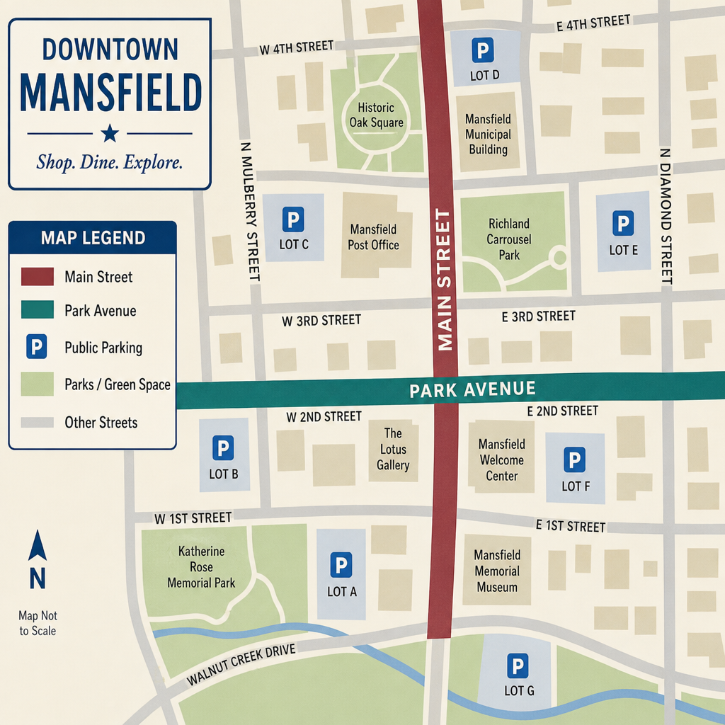
As Mansfield completes its 2026 Main Street Transformation, residents and visitors should understand how the redesigned streets affect access to downtown businesses, public buildings, pedestrian crossings, and nearby parking areas. The changes extend beyond Main Street itself, making it important to check current conditions before traveling through downtown Mansfield and the surrounding Richland County area.
Call (567) 210-2606 or request a free consultation today to speak with an experienced Mansfield personal injury attorney at Buckeye Law Group.
Where Can Mansfield Residents Find Official Roadway and Construction Updates?
The Main Street Improvement Project covers Main Street between First Street and Sixth Street, along with Park Avenue between Main Street and Diamond Street. The improvements include roadway resurfacing, updated traffic signals, redesigned pedestrian crossings, accessible sidewalks, and new public gathering areas. For accurate information about roadway access, parking restrictions, and remaining construction activity, residents can consult:
- City of Mansfield: Official municipal announcements, roadway closures, construction notices, and public works information.
- Downtown Mansfield, Inc.: Downtown improvement information, business-related announcements, and community updates.
- Destination Mansfield: Downtown events, visitor information, and announcements concerning the Main Street Transformation.
On November 6, 2026, the city and Downtown Mansfield, Inc. are scheduled to celebrate the project with a 5 p.m. ribbon cutting at the South Arch near Main Street and Park Avenue West. Visitors attending the celebration should anticipate additional pedestrian activity and confirm parking arrangements in advance. The scheduled event does not guarantee unrestricted access to every nearby street or parking space.
Navigating Central Park, Park Avenue, and Downtown Mansfield
Drivers familiar with Mansfield’s former one-way streets should pay particular attention when approaching Central Park and the intersections connecting Main Street with Park Avenue. The redesigned roadway introduces two-way traffic patterns, updated lane markings, and pedestrian improvements intended to make downtown destinations more accessible. Several locations deserve additional attention:
- Main Street between First And Sixth Streets: Watch for the redesigned traffic flow, updated intersection controls, and pedestrian crossing locations.
- Main Street And Park Avenue: Allow additional time to recognize the new approach directions and turning movements near Central Park.
- Central Park Pedestrian Connections: Be attentive to pedestrians using the redesigned crossings and follow posted signs and signals.
- Nearby Downtown Businesses And Public Buildings: Confirm the appropriate entrance, parking area, and drop-off location before traveling.
The city also planned pedestrian-friendly speed tables connecting the two halves of Central Park across Park Avenue. Drivers should observe the finished traffic controls and remain alert for people crossing the roadway. These improvements are intended to support safer travel, but no street redesign eliminates the possibility of a collision. Motorists must continue to exercise reasonable care, maintain awareness of surrounding traffic, and yield when required by Ohio law.
What Should You Do If a Traffic Accident Occurs Near Mansfield’s Main Street?
Changes in roadway configuration can create unfamiliar driving situations, particularly for motorists accustomed to previous traffic patterns. If a vehicle collision or pedestrian accident occurs along Main Street, Park Avenue, or another downtown Mansfield roadway, the following steps may help protect everyone involved and preserve important information:
- Check For Injuries And Request Emergency Assistance When Necessary: Call 911 if someone requires emergency medical help or if there is an immediate threat to safety.
- Avoid Creating Additional Roadway Hazards: If it is safe and lawful to do so, move out of active traffic and follow instructions from responding authorities.
- Document The Accident Location: When safe, photograph vehicle positions, roadway markings, traffic signals, crosswalks, construction signs, and other relevant conditions.
- Record The Surrounding Traffic Controls: Note whether temporary construction devices, permanent signals, or recently changed lane markings were in place when the collision occurred.
- Preserve Relevant Evidence: Keep photographs, witness contact information, medical documentation, repair estimates, and insurance communications.
- Seek Appropriate Medical Evaluation: Some injuries may not be immediately apparent. Follow the guidance of qualified healthcare professionals.
A roadway improvement project does not automatically establish that the city, a contractor, or another party is responsible for an accident. Any potential negligence claim requires careful consideration of the available evidence, the circumstances of the collision, and applicable Ohio law.
Mansfield and Richland County Resources Following a Downtown Traffic Accident
Individuals involved in a motor vehicle accident near Mansfield, Ohio’s Main Street Transformation project may benefit from the following local agencies and resources, which provide assistance with accident reporting, emergency services, medical care, and obtaining documentation that may be relevant to a personal injury claim.
30 N Diamond St, Mansfield, OH 44902
- Emergency assistance: 911
- Non-emergency dispatch: (419) 522-1234
- Police Records Division: (419) 755-9770
The Mansfield Division of Police provides law enforcement services and information about obtaining police records. Individuals requesting documentation should contact the investigating agency to determine whether an official crash report is available.
Ohio Department of Public Safety — Crash Report Search
Search Ohio Traffic Crash Reports
The Ohio Department of Public Safety provides an online system for searching crash reports submitted by Ohio law enforcement agencies. Reports may take up to six weeks to appear in the database. The online versions are provided for statistical purposes and are not official certified accident reports. Individuals who require an official report or supplemental information should contact the investigating law enforcement agency.
335 Glessner Avenue, Mansfield, OH 44903
- Phone: (419) 526-8000
OhioHealth Mansfield Hospital provides emergency and other medical services for residents of Mansfield and surrounding Richland County communities. Anyone experiencing a medical emergency should call 911 rather than delay treatment to arrange transportation.
Richland County Common Pleas Court and Clerk of Courts
50 Park Avenue E, Mansfield, OH 44902
- Common Pleas Court: (419) 774-5570
- Clerk of Courts: (419) 774-5540
The Richland County Common Pleas Court handles qualifying civil matters, including personal injury litigation within its jurisdiction. The Clerk of Courts maintains court records and provides information regarding court filings and procedures. Residents visiting the county administrative building should confirm their parking and entrance arrangements because its location on Park Avenue East places it close to the redesigned downtown corridor.
How Can Mansfield Residents Report Unsafe Conditions After Construction?
Even after the major roadway improvements are completed, residents may notice problems involving damaged signs, pavement defects, pedestrian access, or visibility at intersections. The City of Mansfield Service Request Center provides a mechanism for submitting municipal service requests and tracking their progress.
When reporting a nonemergency roadway concern, provide the location, nearby intersection, description of the condition, and relevant photographs when available. Report immediate hazards that threaten public safety through the appropriate emergency or public safety channel rather than relying on an online service request. Clear reporting can help city personnel assess potential hazards and determine whether further inspection or corrective work is appropriate.
Supporting Safer Travel Through Downtown Mansfield
The Main Street Transformation represents a significant investment in Mansfield’s downtown infrastructure. Its redesigned roadway, pedestrian connections, and public spaces may change how residents travel between local businesses, Central Park, and surrounding neighborhoods.
For motorists and pedestrians, the most practical approach is to stay informed about current road conditions, follow posted traffic controls, and remain attentive to changing traffic patterns. For those injured in a downtown Mansfield traffic accident, documenting the surrounding roadway conditions and obtaining appropriate medical care can also help preserve information relevant to an insurance claim or potential legal matter.
Call (567) 210-2606 or request a free consultation today to speak with an experienced Mansfield personal injury attorney at Buckeye Law Group.
Legal Disclaimer: This article is provided by Buckeye Law Group for general educational and informational purposes and should not be considered individualized legal or medical advice. The information addresses Mansfield, Ohio’s 2026 Main Street Transformation project, downtown roadway improvements, changing traffic patterns, pedestrian safety, and related personal injury considerations affecting Mansfield and Richland County residents. Any discussion of Ohio traffic laws, negligence, accident reporting, insurance coverage, potential compensation, or legal filing deadlines is intended to provide general guidance. Every personal injury claim depends on its specific facts, available evidence, applicable law, and individual circumstances. Determining liability and the potential right to compensation requires a careful evaluation of those factors. Reading this article or contacting Buckeye Law Group’s Mansfield personal injury attorneys does not, by itself, establish an attorney-client relationship. Individuals seeking advice about a particular accident or injury should consult a qualified Ohio personal injury attorney. Past case results do not guarantee or predict future outcomes.
Mansfield’s Main Street Transformation: What Drivers and Pedestrians Should Know About Downtown Traffic Changes in 2026
As Mansfield completes its 2026 Main Street Transformation, residents and visitors should understand how the redesigned streets affect access to downtown businesses, public buildings, pedestrian crossings, and nearby parking areas.
Toledo’s Douglas Road and Monroe Street Intersection Improvements: What Drivers and Pedestrians Should Know in 2026
The City of Toledo identifies the Douglas Road and Monroe Street intersection as a 2026 improvement project intended to support pedestrian safety, driver safety, and better pavement conditions. For people
Springfield’s South Limestone Street Safety Improvements: What Drivers Should Know
South Limestone Street in Springfield, Ohio, is the focus of safety improvements intended to reduce conflicts between vehicles entering, leaving, and traveling along the corridor. The Ohio Department of Transportation’s
Middletown’s 2026 Safe Streets and Roads for All Initiative: What Residents Should Know
Middletown, Ohio’s Safe Streets and Roads for All (SS4A) effort is best understood as a road-safety planning-and-delivery process funded through the U.S. Department of Transportation. For residents following this community
Euclid’s Lakeshore Boulevard Pedestrian Safety Improvements: What Drivers and Walkers Should Know
Euclid’s Lakeshore Boulevard pedestrian safety improvements aim to enhance roadway visibility, provide safer crossing opportunities, and strengthen connections between Downtown Euclid, Sims Park, and the Lake Erie waterfront. The City
Cincinnati’s Victory Parkway Safety Improvements: What Drivers and Pedestrians Should Know in 2026
Cincinnati’s Victory Parkway Improvement Project represents a significant investment in roadway safety, pedestrian accessibility, and transportation infrastructure. Overseen by the Cincinnati Department of Transportation & Engineering (DOTE), the project includes
What Greater Akron’s latest crash data reveals about roadway safety and serious injuries
Greater Akron’s latest regional crash report shows fewer crashes overall, but serious injuries remain a concern. The Akron Metropolitan Area Transportation Study’s 2022–2024 analysis separates encouraging declines in fatalities from
Why Is St. Clair Avenue One of Cleveland’s Most Dangerous Roads? Crash Data and Safety Improvements Explained
St. Clair Avenue’s danger comes into focus when you look beyond fender-benders to deaths and life-changing injuries. Cleveland reports at least 14 people killed and 79 seriously injured between East
Dayton’s 2026 Road Safety Action Plan: What Local Crash Data Reveals About Dangerous Driving Conditions
The City of Dayton, Ohio, has adopted a comprehensive Safe Streets and Roads for All (SS4A) Safety Action Plan to address traffic fatalities, serious injuries, and hazardous roadway conditions throughout
Cleveland’s 2026 Daylight Saving Time Change: Earlier Darkness, Pedestrian Safety, and Ohio Traffic Laws
Cleveland’s daylight saving time ends on Sunday, November 1, 2026, at 2:00 a.m., when clocks move backward one hour and Northeast Ohio returns to Eastern Standard Time (EST). While the

Buckeye Law Group represents people injured in auto accidents, slip and falls, workplace accidents and more in Ohio. Contact us today to learn more.
© 2026 All Rights Reserved | The Buckeye Law Group Inc. Privacy Policy Sitemap
Office Locations
- Akron Office 388 S Main St #400 Akron, OH 44311 (330) 426-0288
- Cincinnati Office 201 E 5th St Ste 1910 Cincinnati, OH 45202 (513) 547-2445
- Cleveland Office 127 Public Square Ste 1540 Cleveland, OH 44114 (216) 677-5490
- Columbus Office 20 E Broad St Suite 300 Columbus, OH 43215 (614) 482-3793
- Dayton Office 70 Birch Alley Ste 240 Dayton, OH 45440 (937) 884-4474
- Euclid Office 25701 N Lakeland Blvd Suite 113-C, Cleveland, OH 44132 (216) 405-2626
- Mansfield Office 305 E Main St Ste 6A, Mansfield, OH 44904 (567) 210-2606
- Findlay Office 7430 Timberstone Dr unit 101a, Findlay, OH 45840 419-873-5119
- Mentor Office 7537 Mentor Ave Ste 101, Mentor, OH 44060 (440) 306-3536
- Middletown Office 300 N Main St #400, Middletown, OH 45042 (326) 800-9150
- Parma Office 1257 Rockside Rd #A, Parma, OH 44131 (216) 279-1664
- Springfield Office 2100 E High St Ste TL3, Springfield, OH 45505 (937) 806-5791
- Toledo Office 3950 Sunforest Ct Ste 200, Toledo, OH 43623 (567) 483-3883
- Westlake Office 26404 Center Ridge Rd Ste B2, Westlake, OH 44145 216-247-0565
- Whitehall Office 5340 E Main St Ste 203, Whitehall, OH 43213 (380) 257-5206
- Youngstown Office 306 Churchill Hubbard Rd, Youngstown, OH 44505 (234) 225-0683
Contact Us
© 2026 All Rights Reserved | The Buckeye Law Group Inc. Privacy Policy Sitemap